- Screen Reader Access
- Skip to : main content / navigation
-
- Text Size
- Home
- Sitemap
- Contact us
- हिंदी


I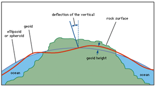 |
 |
Geoid is an equipotential surface of the Earth's gravity field, which approximates the mean sea level. It is perpendicular to the direction of the gravity pull of the earth. Since the mass of the Earth is not uniform at all points, the magnitude of gravity varies and the shape of the geoid is hence irregular. The spheroid or the reference ellipsoid is a smooth elliptical model of the earth that describes the true shape of the earth. Due to the subsurface density inhomogeneities, the shape of the geoid with respect to the spheroid varies from place to place. The variation in height of the geoid with respect to the spheroid is defined as the geoid anomaly.
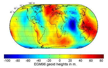
Recent gravity models and satellite based observations show that geoid rises and falls over spheroid as much as -100 m to + 100 m. The undulations in the geoid are suggested to be caused due to subsurface density heterogeneities and long wavelength geoid anomalies are often interpreted as present-day mantle density heterogeneities. These have a direct bearing on the physical and chemical properties of deep mantle and processes that are responsible for phenomena such as mantle convection, plate tectonics, etc. Thus elucidating large wavelength geoid anomalies is of significance in global geodynamical studies.
Positive long wavelength geoid anomalies are generally concentrated over subduction zones and hotspots. Geoid highs over active subduction zones are inferred as resulting from a dominating positive mass anomaly of cold, upper mantle slabs compared with a low from dynamic topography. Association of positive geoid anomalies with hot spots and associated density anomalies, going down to Core-Mantle Boundary (CMB) have also been explained and modeled. In contrast however, there is no general consensus regarding the source of long wavelength geoid lows. Analysis of the global lows indicates that they are correlated with locations of Mesozoic subduction. Geoid lows have also been shown to be underlain by high seismic velocities near the base of the mantle. However, in the same region, the upper part of the mantle is marked by anomalously low seismic velocities.
One such geoid low, the largest one, is centered around the south of India. Several suggestions have been made to explain this geoidal low. Some researchers think that it is caused due to the depression in the Core-Mantle boundary, while others propose density heterogeneities in the upper mantle. It has also been proposed that it is produced due relict of earlier subduction. All the studies are, however, in agreement that it is a deep-seated earth structure.
Against the above backdrop, NCAOR has planned a major initiative to study and understand this deep-seated, globally debated earth structure. A two-fold approach is proposed to adopted: as the first step, a detailed marine geophysical study of the area along a series of transects across the low, from Chagos-Laccadive Ridge in the West through the Southern part of India and Sri Lanka, and across the Bay of Bengal to the western offshore region of Andaman-Nicobar islands is proposed to be carried out. Concurrently it is planned to deploy two kinds of seismic arrays along with global seismic network (like IRIS), in the area -one along a North - South line, over the islands of Chagos - Laccadive, Sri Lanka and southern India, and the other, along a transect orthogonal to it, for initiating continuous measurements.

